
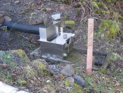
A common problem we encounter in talking to customers about using weirs is lack of understanding of where the correct point of measurement is.
Unlike a flume, where the point of measurement is in the body of the flume itself, for a weir, the point of measurement is upstream of the weir itself with the gauge zero occurring above the floor of the weir pool (channel floor).
Point of Measurement
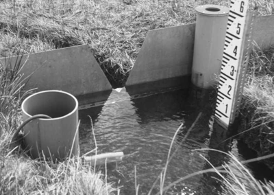
In a weir, the point of measurement is upstream of the crest because of the drawdown in the water’s surface as it approaches and then passes over the weir’s crest. Research has shown that to avoid the drawdown, the level measurement must be taken upstream of the weir crest at a distance of 3 to 5 times the maximum head, Hmax.
Measuring at the Face of a Weir
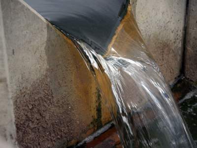
Measuring at the face of the weir is incorrect. As the water approaches the nappe and the velocity increases, the surface of the water drops. Measuring at the face of the weir, where the decrease in the water’s surface is greatest will, therefore, only give a general indication of flow.
In an installation where the face of the weir is used as the point of measurement, the accuracy cannot be expected to exhibit the +/-2% accuracy, which is standard for weirs – even if all other factors are optimal for flow measurement. The accuracy of the installation will be worse but not in by a quantifiable amount.

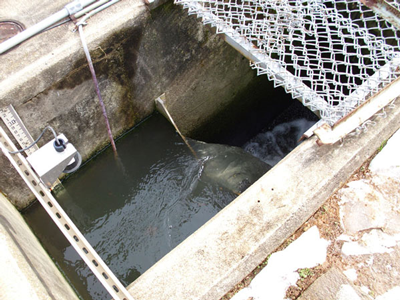
Installations using temporary or portable weir plates are most likely to suffer from the problem of weir face measurement. Resellers and manufacturers with little flow experience offer weir plate products where the gauge is engraved or applied to the face of their weir plates. While this does make it easier for the user to get a level reading, the reading is not accurate.
Gauge Zero in Weirs
To develop a proper weir pool, the crest of a weir must be set a minimum of 2 times the maximum anticipated head, Hmax, above the channel floor. This elevation is the zero reference elevation for head measurement and the gauge zero must be set to this level.
Checking Gauge Elevation
Unlike most flumes where the floor of the flume is as the same elevation as the gauge zero, a weir will have some body of water below the gauge zero at all times. It is not uncommon to want to measure from the surface of the water at the point of measurement to the floor of the channel and simply deduct the height of the crest above the channel floor to determine the head in the weir.
There are two problems with this, though: the weir crest could have settled / shifted / undergone ground heave, or sediments could have accumulated in the weir pool – raising the floor elevation. In either case the gauge would no longer read the correct level.
It is important, therefore, that the location and elevation of the staff gauge should be checked as part of the periodic maintenance of any weir installation.
Hb Location for Transition Submergence
In a weir, the location of the Hb location (the downstream head used to determine the submergence of a weir) is not fixed in the same way the point of measurement, Ha, is.
In Submerged Weir Discharge Studies, Villemont recommends that Hb be measured downstream of the weir, just past the turbulence of the nappe entering the downstream water. Generally this is defined as being 6 to 10-feet [1.83 – 3.05 m] downstream of the weir crest.
For both the primary (Ha) and secondary (Hb) points of measurement, the zero reference elevation of the weir crest is used for the gauge zero. In this way a proper submergence ration can be obtained.
*Insert and Cuttback style Palmer Bowlus flumes are the exception here. In these configurations, the point of measurement is upstream of the throat / ramp of the flume.
**Palmer Bowlus and RBC flumes are the exception with the gauge zero elevations occurring above the flume floor.
Images: Yadkin Valley Sewer Authority, Maine Geological Survey, The Lancaster Environment Centre
Source: Villemonte, J., Submerged Weir Discharge Studies, Engineering News Record, December 25th, 1947
Related Blog Posts
-
Expert Insights
-
Expert Insights
-
Expert Insights


Explore more insights in our blog.
LOCATIONS IN ATLANTA, GA & BOISE, ID